Sunday, September 10, 2017

Costa Rica bike tour

Despite our conviction that we all need to be flying less, not more, Brie and I made a holiday trip to Costa Rica. Neither of us had been to Central America, and we had an invitation to stay from a coworker of Brie's who's built a life there for the time he's not in Alaska.
Early in our planning, we considered riding bikes (we had about ten days before visiting Brie's friend), but a quick search scared us off -- blogs and guides warned of crazy drivers and pothole-filled roads. When we came back to the idea months later, it seemed opinions were split. One couple described past trips by bike but added that they don't ride there anymore and wouldn't recommend it to anyone. A Dutch hotel-owner who rents mountain bikes proclaimed bike touring was an excellent choice for everyone. Pura Vida! We decided to give it a shot.
In the end, most of what we read, the cautionary as well as the optimistic, proved true. And in the end we came to think cycling can be great -- if you do it a certain way. Here, then, is our contribution to the small Googleable canon of writing on bike touring in Costa Rica.
Beginning with some basics: After our third day on the bikes, we joked that each day had offered a hard lesson in a specific area, first route-finding, then topography, and then the sun.
We had heard that Costa Rica did not have street names or addresses, but this seemed implausible to me, and our fairly detailed map labeled both urban streets and rural routes. What we learned that first day is that Costa Rica lacks signage. Dramatically. On top of concerns over biking out of a city of a million people, we suddenly found we could not rely on street names for any guidance. Stuck for dozens of blocks on the Pan-American Highway where it slowed to pass through San Jose, we did not pass a single street sign. We turned off, on a hunch, on a street that looked the right size. Later we learned to navigate with Google Maps, noting the angles at which roads intersected and visible landmarks like cemeteries. (In a game-changing moment, we learned that Google Maps will locate you without using cellular data.) From then on, we were never lost. At times we used Google Earth, too, the satellite photos of which showed even the smallest dirt tracks.
On our second day, we biked up Volcan Irazu, a climb of about 6,000 vertical feet. I knew this was a huge climb, and we chose to do it. What I did not know is that much of Costa Rica is up and down, and that the roads are built with incredible grades. Even on paved roads, we were often in our tiniest granny gears, at times struggling to keep the front wheel on the ground. The near-constant hilliness made our route unrealistic for the time we had.
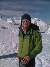
On the third day, down from the cooler weather of the volcano, we learned the intensity of the mid-latitude sun. Before I had time to notice, the back of my right calf was burned red. Brie's forearms turned the same color. We took our breaks in the shade and, when we reached Orosi in the early afternoon, hurried from the sun as one might from sun-baked sand on a hot beach.
None of these, of course, is a reason not to bike as much as a consideration to factor into plans. Same with the roads -- choose wisely. We'd been advised not to ride on the Pan-American (and warned when we got to Costa Rica that it was illegal), and this seems like good advice. Riding the main road along the Pacific coast seemed relatively safe, but was not much fun. Two things we had not considered were air pollution and dust. Riding from Orosi toward the coast, we had to pass through the southern part of Cartago on busy roads, and the filthy exhaust from trucks and cars alike literally made it hard to breathe for hours of riding. Despite the country's commitment to environmental health, there seems to be little regulation of vehicle-based pollution. Later, on the flatter plain near the coast, we were left struggling to breathe again -- and covered in thick dust -- after riding on a dry, heavily traveled dirt road.
For a truly enjoyable trip, I would try to avoid all of these, and string together instead as many small, rural routes as possible. Buses can help with this. The public buses run often, go everywhere, and, as I understand it, will take bikes if there's room. And they're super cheap. Even a shuttle or a cab would likely be affordable.
One of the questions we had, especially going over the busiest time of the year, was what kind of towns would have affordable places to stay and whether we would need to book in advance. We wanted flexibility in choosing our route and pace, but also didn't want to end up without a place to sleep when the sun went down. We decided to bring a tent (and small stove, sleeping pads, and sleeping bag), which proved useful, even if our guidebook's suggestion that most accommodations would allow camping proved untrue. The two nights we camped, we did so on the generosity of people we met. The nights we wanted to stay in towns, we never had trouble finding room with little notice. We stayed one night at an Airbnb, which was great; Couchsurfing seems like a viable option, too. Riding some random steep hill, I sometimes imagined how light our bags would be without tent and sleeping gear. I'm glad we brought them, for the freedom they allowed, but I'm sure one could plan a cool route that allowed carrying very little gear.
We rode good, old mountain bikes we bought off MercadoLibre (thanks for the tip Jos). The man we bought them from had only listed one, but offered his own commuter bike, too, when he realized we were coming from the US and hoping to tour. When we met him outside our hotel, he said he knew what it was like to travel abroad and have to figure everything out new. He told us of some beautiful spots to ride and of bike shops where we could get geared up cheap. His kindness was one of the best parts of our trip. Thank you, Oscar.
Buying a helmet and back rack, water bottles and spare tubes, I was struck at the range in prices. The crowded shop Oscar had recommended sold bikes for $100, but also had a $5,000 fat bike on display. We could buy water bottle cages for $2 each, or $20. Kids came in with busted brakes, and then a woman who'd raced the Ironman and worked for Deloitte and Touche.
Our two-week visit offered only a superficial look, of course, but I continued to be struck by the range of lives Costa Ricans lived. Some had new cars and vacations at the beach. Others earned tiny wages, spent long hours in the sun, and got around on horseback. In parts of Costa Rica -- around Monteverde, for instance -- the lingua franca was English and the prices listed in dollars. In other parts, it was only Spanish and colones.
Biking was our window onto this, a slow path through the countryside and an excuse for meeting people. There is no other way we would have felt the complete satisfaction -- after pedaling through the still-sleeping city, after gallo pinto and coffee made in front of us with a cloth filter, after the waves and whistles and horns of passing cars, after countless switchbacks and eight hours on the bike -- of reaching the crater of Irazu a half-hour before closing.

Wednesday, January 18, 2017

the Circle-Fairbanks historic trail

 
Brie and I hoped this trip would warrant a write-up in the News-Miner. The Circle-Fairbanks Trail isn’t particularly remote, but it’s almost 60 miles long and no one we knew had done it. Just finishing it would be worth a story. Alas, not finishing it probably isn’t, so here’s a blog post.
I had explored the trail from both ends before. Several years ago, I hiked a few miles in from the 12-mile Summit end looking for caribou. I didn’t know how to field dress a caribou then, but I wanted to hunt and none of my friends could come, so I went anyway. I thought if I shot one, I would figure it out. A few years later, I rode my motorcycle in from the Cleary Summit end, splashing through mud puddles and dropping my bike so many times I wore down the battery.
I’ve wanted to do the whole thing for years, imagining it being fun on a mountain bike in a dry year. Or on foot. A few weekends ago, Brie and I hiked part of it when we walked from Cleary Summit to Chatanika Lodge and back. The trail was wide and gradual, and someone on a 4-wheeler had made a track in the few inches of snow. The walking was easy.
We decided to hike the whole route over three days Thanksgiving weekend. When I mentioned it to people, a few had fond memories of parts of the trail, but none had done the whole thing. To me it seemed like an obvious trip – a short drive from Fairbanks, with miles and miles of ridges above treeline. It didn’t have cabins like the White Mountains, but otherwise seemed ideal for an adventure on skis or fat bike. We arranged to have a friend drop us off at 12-mile Summit. We would walk back to a car left in Fairbanks.
Without leaving a car at the beginning, we would have little option but to complete the trip once we started. I found the trail on a topo map and studied Google Earth until I had cross referenced the trail with the landscape.
I knew we were strong enough to do it. We’d done some long hikes and runs over the summer. And we’d camped in similar temperatures north of the Brooks Range last fall. But neither of us had exactly gone backpacking in Alaska in November, and it wasn’t clear how we would stay warm, or how fast we could move. As Thanksgiving neared, we studied the forecast and debated what gear to bring.
In the end, we didn’t have all the answers, but I was confident we could figure things out as we went. It had been a while since I’d attempted something with this much doubt, a result, I suppose, of choosing doable routes and always being prepared. Equipment can be a crutch for lack of skills, and I’ve tried on summer trips to learn what I can do without. But the skill of not getting into trouble is different from the skill of getting out of it, and I had rarely exercised this second skill, if indeed I had it. We both dream of doing much bigger trips. At some point we'll need to test ourselves. And if something truly went wrong on the trail, we could always hike out to the road.
We started from 12-mile Summit a little before noon. The car’s thermometer said minus 11, and the wind blew strong over the ridge. A few bands of caribou grazed on a distant hillside. A dozen more crossed the trail in front of us. We walked fast with our faces covered. The trail was easy to follow and tracked by snowmachine and 4-wheeler. We dipped into a slight draw. The wind let up and soon we were shedding layers.
A little while later, with daylight fading, we stopped for water and a snack. I struggled to get my mitten off. Once I did, I couldn’t open a Ziploc bag of chips. I swung my arms and ran down the trail, suddenly aware of how delicate a balance was needed to stay warm. Wearing too many layers made you sweat, which made it harder to stay warm once you stopped. Wearing too few layers made your core temperature drop and made it harder to keep fingers and toes warm. Moving would generate heat, but only if you kept eating. Somehow I had let myself get cold enough that now I could not bend my thumb. I was glad my life did not depend on my ability to build a fire, as I could not have struck a match. 
I managed to open a packet of hand warmers and slip one into my mitten. Brie zipped my jacket for me and we kept moving.
I’ve often carried hand warmers on winter trips, but can count on one hand the times I’ve used them. I think I see them as unnatural, and I don’t like the idea of relying on them. But now I was glad to have them.
Somewhere along the trail, we agreed to make a list of things to do differently next time. I already questioned our choice of running shoes. They had kept my feet warm during a 100-mile walk in the White Mountains a few winters before, but now it seemed like one more obstacle to staying safe in this environment. To keep our feet warm, we would have to move constantly.
Brie asked how far we should go. I proposed that 15 miles today would leave a little over 20 miles for the next two days. The whole trail, according to the pamphlet we had from the Alaska Department of Natural Resources, was 58 miles. It ran mostly along ridges and was the summer route, a hundred years ago, for miners traveling between Circle and Fairbanks. (The winter trail followed the Chatanika River.) I’d heard there were roadhouses, but I thought of those guys now, braving the cold and wind in whatever gear they had.
We came to a fork in the trail. We had not bothered to follow our path on the map, but either place we might have been, left would work. The trail was wider to the left, and the 4-wheeler tracks turned left, so we did too. Soon we came out of the forest and onto a ridge. We could feel the rocks under the snow. The 4-wheeler tracks faded out, and then the trail they had followed. The wind blew hard. We shuffled to a clump of willows and hid in the lee to study the maps. I added a puff jacket and Gore-Tex shell and pulled the hood over my head.
We could see a trail climbing a hill off to the right, and another glimpse of a path along the ridge that followed from the hill. We didn’t know of any other trails out here, so we sidehilled over to the trail. I felt the wind blowing through the open mesh of my shoes. We wore our warmest clothes and moved fast.
Climbing, we warmed again, and I stripped off jackets. Willows grew up through the track, clearly less defined than a mile before. At the top, we put on headlamps and followed the trail between mounds of granite. At times, a few feet of straight line was all that differentiated the trail from the tundra. The trail split. We followed one fork until it faded out, and then backtracked and followed the other until it did the same.
Sometimes I think of running whitewater as a metaphor for situations in life. There are times in a canoe when you cannot stop and think. You are heading downstream regardless, and you just have to make the best choices you can.
I made a mental check and concluded we were still okay. We could camp, make hot food, find the trail again with map and GPS. But we didn’t have much time.
The ridge was windy, and although it was only 4:30, it was almost night. A few miles off, we could see lights on the highway. We knew it would be less windy if we got off the ridge, but we still had to choose whether to head north toward the road or south toward where we assumed the trail must be. We chose south, but only because it seemed more sheltered. We moved fast, pushing our way though willows and grass toward the trees silhouetted by our headlamps. When we found a spot relatively sheltered and relatively flat, we stopped. Setting up the tent, the excitement I had felt at finding a used winter tent for cheap was gone. I simply wanted it to work.
Inside, we huddled in sleeping bags, Brie trying to warm her feet and me hoping desperately that they were not damaged.

Once we warmed up, we figured out where we were. In the morning, we’d called the number on a sign posted by a trapper and learned that he did have traps out, and that they would pose a risk to free-running dogs. We considered bailing, finding a different hike, and then decided after some time to keep our plan and leave the dogs home. At the end of the call, I’d thanked the trapper as he started to say something else, and a few times I wondered what he might have said. That no one travels the full length of the trail?
We fired up the stove and melted enough snow to fill hot water bottles and foil bags of dehydrated food, which we tucked against our bodies. We slept with jackets on and both woke around midnight, overheating. Despite the long night, we slept until it got light. My little thermometer read five above.
Because the easiest way to the road was to keep following the trail, and because we still held some hope we might complete the route, we backtracked to where we’d climbed the ridge and regained the trail. Willows grew up in the track, trees lay across the trail, and rusted traps hung from angled spruce poles. We knew from our map that this was the trail, but the mileposts promised in the pamphlet – and which we’d seen the day before – were nowhere to be seen. We walked hard and fast along the ridge, buoyed by the sun, then dropped into the trees, down to the creek where we would choose to continue or not. Halfway down the hill, amid burned black spruce, we found a milepost telling us we had 45 miles to go.
At the bottom of the hill, we found milepost 43. The trail continued up a hill to the south. The highway lay to the north. We got out the map and frozen grilled cheese. The temperature had dropped as we descended, and the low-angle sun hid behind a ridge.
Our record of meeting our outdoor goals is pretty good. We didn’t reach the top of a mountain in Sitka for lack of time, and we came nowhere near the Sawtooths, where the research we should have done became clear only once we were there. But mostly we’ve accomplished what we set out to do. Neither of us likes to quit.
In camp, Brie had commented that if we did keep going, we could walk all night rather than camp again. I thought of that now. If we chose to push on, we would need that kind of energy. We would need to be excited by the challenge and confident we could meet it. Between us we had three pairs of toe warmers. Each pair lasts six hours. I thought I could do without, but I wasn’t sure. I ate some Fritos and ran circles to warm up. If last night was whitewater, this was an eddy, from which we could take out and portage.
The trail followed a long ridge for a dozen miles, then curved around a drainage and climbed a hill. The trapper had told us he’d been out 25 miles, which left up to 18 miles untracked. The sun would set in a few hours. If we could hike all night, if we could find the trail in the dark, if we could stay warm… There were too many ifs, so we hiked out to the road and caught a ride back to Fairbanks.
Brie has concluded I give too much credence to Google Earth, but the problem might be that I haven’t trusted it enough. Scanning the route before we left, I’d noticed that the trail, visible on both ends, disappeared in the middle. I rationalized this as the result of different quality images, or images taken in different seasons.
I also had not registered the bold warning in the DNR pamphlet explaining that although the trail had been marked and cleared, “there is not a well defined tread the entire length.” Or the fact that the pamphlet was made in 1986.
Back in Fairbanks, we told a few people about our adventure and got the same response. Heard of it. Never heard of anyone doing it. Which has left us even more determined than ever.